Sunday, September 11, 2011

Ten Years Later


On most days I can barely remember what I ate for lunch the day before let alone something that occurred in the prior month or year.  But I can tell you exactly where I was on September 11, 2001.  Even though ten years have passed, that fateful day remains engrained in my memory.

It had been one of those burning-the-midnight-oil kinds of nights and I never made it to bed until the wee hours.  Suffice it to say that I didn’t surface until 10ish that morning.  I jumped online to conduct my morning ritual of checking email and received an instant message from a friend, “Can you believe what is happening in our country right now?”  I turned to the TV and saw the North Tower collapsing.  I remain parked there for a good portion of the remaining week, not wanting to watch or believe, yet numb and unable to move.  My first thought was for the safety of friends and family who lived in New York City.  The relief I felt upon hearing of their wellbeing was replaced with heartbreak and tears for the emerging stories of others involved. 

I had just been to New York City for the Memorial Day holiday.  It was our final day in the Big Apple and a gorgeous one at that.  Because of the partly-cloudy weather that had enveloped the city all week, we had not been able to enjoy the view from the top of the World Trade Center (No. 195 on my bucket list).  Now that the fog was gone and the sun out, we decided to return to the Twin Towers.  Upon learning we would have to queue for 1.5 to 2 hours to reach the observatories, we abandoned that idea and returned to Windows on the World for cocktails.  The views of the city below our vantage point on the 107th floor were spectacular, but my cousin had just moved to New York.  I knew I’d be back at a later date to “officially” accomplish my task.  Who knew that three months later the buildings, targeted by terrorist attack, would be gone forever?  The words carpe diem have never ringed more true.

I can’t imagine what the days leading up to September 11 must still feel like for anyone who lost someone that day.  My experiences and memories pale in comparison, yet I ache a decade later.  There have been a lot of stories in the media this week and, even though I’d like to forget, it is something that must always be remembered.  But I knew I didn’t want to do it in front of the TV again and I knew I didn’t want to do it alone.

I headed to our very own Cannonsburg Ski Area, which was one of 16 sites nationwide to host a Healing Field.  The sea of 3,200 flags displayed on the hillside honored those who had lost their lives that day at the Twin Towers, the Pentagon and in a field near Shanksville, Pennsylvania. 


Each represented a September 11 victim and was tagged with their name and story.  I wanted to read them all. 


Again I was reminded of just how fragile life can be and how it can be snatched from any of us without a moment’s notice.

I didn’t interact with the crowd—it wasn’t necessary—yet I was comforted to be amongst those who were there for the same reason.  As we moved through the memorial we also moved forward in our lives, continuing to heal and seizing the day in remembrance and honor of those who have gone before us.


Sunday, September 4, 2011

Rats ... Bats!

One of the things I love about blogging is that it gives me an opportunity to answer some of those “Why … ?” questions which always seem to be rolling around in my head.  Case in point time zones and, more specifically, why some states in the U.S. actually have two different zones.  We first encountered this phenomenon when touring Idaho back in 2002, but I never addressed it then.  When it happened to us again, I decided to do a bit of poking around to discover “Why … ?”

In 1878, a man named Sanford Fleming proposed the idea of dividing the world into 24 equal zones to combat the Earth’s rotation and afford everyone the same number of hours for daylight regardless of where they lived.  Several years later railroads jumped on the bandwagon as they pushed westward and needed standard times to properly schedule their trains.  In 1918, Congress conceded and passed the Standard Time Act.  Four time zones in the United States—Eastern, Central, Mountain and Pacific—became official.

Of course, nothing is ever that easy.  The map dividing our country into time zones doesn’t always follow state lines.  The determination as to how to set the clock became a political matter.  Governments of towns and villages located at the points where a time zone intersects a state ultimately decided in which they wanted to be. 

There are actually 13 states comprised of two time zones, one of which I was surprised to learn is Michigan.  Most of the Mitten State is in the Eastern Time Zone, but the counties of Dickinson, Gogebic, Iron and Menominee in the western Upper Peninsula are in the Central Time Zone. Who knew?  Kentucky is also one of the two-zone states.  As we travelled south from Lincoln’s Boyhood Home and headed to another national park, we crossed into the Central Time Zone and gained an hour.  I love when that happens!  (Yeah, I know.  That was kind of a long segue ... )

We arrived at Mammoth Cave National Park shortly before noon.  The Visitor Center was teeming with tourists, but that was expected.  Not only was it a holiday weekend, but during peak season the park receives 5,000-7,000 visitors daily.  Although advanced reservations are available for various cave tours, we decided to wing it.  Despite the masses, we had no problem scoring tickets.  I really wanted to do the six-hour Wild Cave Tour which allows you to go off trail, but Mark wasn’t eager to jump into that hole.  We compromised, settled on the Historic Tour, and journeyed for two hours over two miles along a route that has been followed for 200 years.  Consider yourself warned … taking photos of caves in low light conditions in a place that doesn’t allow camera tripods is bad enough, but throw in having to keep pace with 120 of our newest friends and pictures are bound to be sketchy.


Even before we descended through the historic natural opening discovered in 1798, we felt a change in temperature.  Needless to say, the cool 54 degrees was a welcomed relief from the oppressive heat topside. 


We traveled along the main underground avenue and learned about the cave’s formation, history and unique features.


Whoever was responsible for naming the caverns of central Kentucky was spot on.  With over 390 miles of surveyed passageways, Mammoth Cave is the longest known cave system in the world.  And geologists believe there could still be another 600 miles of undiscovered tunnels.  Ginormous?  Ya think?  We felt dwarfed upon entering the massive labyrinth but were in total awe.


Mammoth Cave is compromised of limestone and, like most major caves, was formed slowly as the calcium carbonate was dissolved by water seeping into the ground.  As the water worked its magic, the limestone eroded and a honeycomb of underground passageways and rooms emerged.  Interestingly, this is an ongoing process and the cave continues to form today.  The limestone ridges are capped by a protective upper layer of sandstone, almost 50 feet thick in some places, which render this cave system very stable.


The history of these caves dates back thousands of years, from Native American Indians who hunted the Green River valley to European settlers who mined for saltpeter to make gunpowder.  By the end of the War of 1812, the notoriety of Mammoth Caves had grown and more people started to visit.  Stephen Bishop soon became one of its well-known guides. 


Bishop was an African-American slave of then-cave owner Frank Gorlin.  At Gorlin’s directive, he explored many miles of the vast cavern, was one of the first people to make extensive maps of the system and named many of the cave’s features.  He began guiding visitors at the age of 17 by lamplight and continued to do so until he died in 1857.  He is interred in the park’s cemetery located above the cave.

Photo from nps.gov

Our present-day tour was lit by the conveniences of modern technology and led by park rangers who detailed the old saltpeter mine works and pointed out the cave’s unique formations. 


The website had warned that this was not the tour for those prone to fear of heights or claustrophobia, as was evidenced by the Bottomless Pit—which drops 105 feet deep—and Fat Man’s Misery.  Donut lovers beware!


The large cavern which follows this narrow tunnel is actually 280 feet below the surface.  Though it has been excavated and is now easier to navigate, when Bishop first explored this area of the cave it was barely large enough for him to crawl through.  When he reach the cavern, he named it the Hall of Great Relief.  Amusingly, restroom facilities have been built at this site.  Coincidence or just a cheesy guide spiel?

As with any ecosystem, Mammoth Cave has its own interactive biological community.  More than 130 forms of life inhabit the cave system and have acclimated to living in darkness.  They include eyeless fish and shrimp, cave crickets and snails.  And bats.  In fact, there are an estimated 9-12 million living in just the Historic section of the cave.  Rats … now you tell me.  Snakes I can handle.  Spiders?  No problem.  But I absolutely abhor mice, and in my mind bats are mice with wings. Good thing we only crossed paths with one of them!


But I do recognize measures must be made to protect nature in all forms and was troubled to learn that White-Nose Syndrome is considered to be present in Mammoth Cave.  While it is not harmful to humans, since the fungus was discovered in 2006 it has been responsible for killing more than 1 million bats throughout the eastern U.S.  In an effort to contain and control it, everyone who participates in a tour is required to walk on bio security mats saturated with Lysol after exiting the cave.

The grand finale of the Historic Tour was Mammoth Dome.  Short of backtracking for two miles and two hours, the Mammoth Dome Tower connecting the lower cave trail to the upper cave trail is the only way out.  Climbing 138 steps of a steep steel tower to transcend a cavernous dome which stretches 192 feet from floor to ceiling?  Okay, I’ll confess to a wee bit of acrophobia here.

Back on top the surface area of the park includes over 47,000 acres of the picturesque hills and woodlands of Kentucky.


They are perfect for hiking, biking, horseback riding, and canoeing or kayaking.  Had we more time and the heat been more bearable, we would have meandered down a trail or two to see more of the native flora and fauna, sinkholes and historic buildings.  We opted instead for an air-conditioned scenic drive around the park, which at one point involved fording the Green River via ferry!


There’s so much more to see and do at Mammoth Cave National Park than what we obviously could accomplish in a half-day.  A return trip is definitely in order.  I may be prone to a fear of heights on occasion, but that won’t stop me from further exploration of what lies underground.  I have no qualms about donning knee pads, a hard hat and head lamp to belly-crawl through rarely-visited muddy passages and explore in the dark.  I just need a willing partner in slime.  Any takers?

Saturday, September 3, 2011

Humble Beginnings


I was born, and have ever remained, in the most humble walks of life.
~Abraham Lincoln

It all started in Arco, Idaho in 2002.  I was in the gift shop at Craters of the Moon National Monument amassing a pile of postcards when I spotted it out of the corner of my eye.  Oh sure, I knew there were national parks in the United States, but until I began to thumb through the pages of the spiral-bound Passport to Your National Parks, I really had no idea of how extensive our National Park Service was.

Yellowstone National Park was established as our nation’s first by an Act signed by President Ulysses S. Grant on March 1, 1872; the NPS was created some 44 years later when President Woodrow Wilson signed another in August 1916.  Today the NPS is compromised of 395 units which cover more than 84 million acres in every state (except Delaware!), the District of Columbia, American Samoa, Guam, Puerto Rico and the Virgin Islands.  They not only preserve the scenic areas of our country, but also share the stories of its people in national parks, monuments, battlefields, military parks, historical parks and sites, lakeshores, seashores, recreation areas, scenic rivers and trails, and the White House.  Whew!  Suddenly there were a lot more places I wanted to see. 

With color-coded maps, pictures and descriptions of a variety of regions, the NPS Passport points me in the direction of its assorted sites.  And, like an international passport, it provides a place to collect cancellation stamps bearing the names and dates of the places to which I’ve been.  In addition to accomplishing things on my Bucket List while traveling, one of my idiosyncrasies became a desire (obsession?) to obtain a stamp in my NPS Passport from whatever happened to be in the area I was visiting.  Five such sites can be found in Kentucky, two of which were in the vicinity of where we’d be.  Let’s roll!

The Abraham Lincoln Birthplace National Historical Park was the first memorial built to honor our 16th President.  That’s right, Lincoln hailed from Kentucky.  Even though he ultimately wound up in Illinois, the Bluegrass State was home to his humble beginnings.  Compromised of two units, this park focuses on Lincoln’s life in the south.  The Birthplace Unit features a symbolic cabin enshrined within a memorial building and the Boyhood Home Unit where Lincoln spent his formative years.  Since we were traveling from the north, we actually stopped at the latter first, but for the sake of chronology I’ll detail the sites in reverse.

At the Visitor Center at the Birthplace Unit we viewed a 15-minute film, Abraham Lincoln: The Kentucky Years, to discover where it all started. 


In the fall of 1808, Thomas and Nancy (Hanks) Lincoln and their year-old daughter Sarah settled at Sinking Spring farm in what is today known as Hodgenville, Kentucky. 


Two months later, on February 12, 1809, Nancy gave birth to their second child in a one-room log cabin.  He was named Abraham after his grandfather. 


Due to an unstable land title, in 1811 the family moved 10 miles northeast and rented 30 acres of the Knob Creek farm.  Lincoln’s earliest memory was of this homestead and helping his father plant pumpkin seeds. 


The reconstructed cabin at this site actually belonged to the Gollaher family. 


Had it not been for his childhood friend Austin Gollaher, who plucked Lincoln from a swollen stream following a flash flood, the great man’s story would have ended here.  But he and his family remained at Knob Creek for five more years until slavery issues and lawsuits over title to Sinking Spring farm led them to Indiana. 

In 1905 Robert Collier purchased the farm where Lincoln was born. Together with Mark Twain, William Jennings Bryan, Samuel Gompers and others, he formed the Lincoln Farm Association to preserve the birthplace and establish a memorial to house a log cabin from the farm; they raised over $350,000 from 100,000 citizens.  John Russell Pope, known for other famous structures such as the Jefferson Memorial in Washington, D.C., designed the Beaux-Arts neo-classical building at Lincoln’s birthplace.  The cornerstone was laid by President Theodore Roosevelt in 1909 and dedicated by President William Howard Taft in 1911, almost 100 years after the Lincoln family moved from Sinking Spring farm. 


Fifty-six granite steps—one for each year of Lincoln’s life—lead to the log cabin inside the building.  While it is old and typical to the area of that time, it is not the original Lincoln cabin.  The memorial building also features 16 windows, 16 rosettes on the ceiling, and 16 fence poles, all representative of Lincoln as our 16th President. 

Having previously toured the Lincoln Boyhood National Memorial in Indiana and the Lincoln Home National Historic Site in Illinois, I knew how Lincoln’s story ended.  With our visit to the Abraham Lincoln Birthplace National Historical Park, I finally learned how his story began.  After I scored a stamp from each site in my NPS Passport, it was time for discoveries of another kind …

Friday, September 2, 2011

The Kentucky State Capitol

Being afforded many opportunities to travel, I’ve actually seen more than the 20 states crossed off aforementioned list.  But because I haven’t yet toured their statehouse, places like California, Nevada, South Dakota, Florida, New York and New Jersey haven’t scored a checkmark.  My list, my rules!  Since that notion is what prompted a trip to the Bluegrass State, its Capitol was the site to which we first headed upon arriving there.

Completed in 1910, Kentucky’s current Capitol is the fourth permanent statehouse constructed since the Commonwealth’s statehood in 1792.  It was built to replace the earlier 1830 capitol building, still standing in downtown Frankfort, which had become inadequate to accommodate the growing state government.  Designed by Frank Mills Andrews, it is considered to be one of the most beautiful capitols in the country.  His Beaux Arts design is a pleasant departure from the many classical Greek and Roman structures I’ve seen in other capital cities.


The exterior of the Capitol is faced in Indiana limestone and Vermont granite.  The pediment above the entrance was designed by Charles Henry Niehaus and carved by Australian sculptor Peter Rossack.  The central figure represents Kentucky, with Progress, History, Plenty, Law, Art and Labor as her attendants.  The animals symbolize agriculture.


The building’s interior is open to visitors and guided tours are available on the hour. We instead grabbed a map and opted to explore on our own.

The capitol rotunda features sculptures of prominent Kentuckians, including Abraham Lincoln, Jefferson Davis, Henry Clay, Ephraim McDowell and Alben Berkley. 


The dome rises more than seven stories in height (180 feet) and was patterned after the dome of Napoleon’s tomb in Paris. 


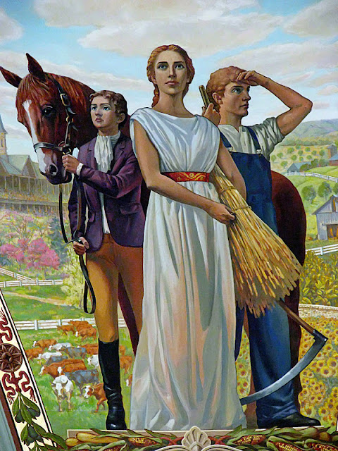
My favorite feature of any capitol building is the murals which depict its history.  The four hand-painted murals in the Capitol’s pendentives (the triangular areas beneath the dome) did not disappoint.  Though it took nearly 100 years for their design to be realized, the story of how they came to be is an interesting one.

 Civitas: The Light of Progress

When the Capitol was originally built, plans were made for muralist Frank Millet—a former Harvard classmate of Kentucky’s then governor August E. William—to design and paint murals in the Capitol rotunda.  Tragically, he died on the ill-fated maiden voyage of the Titanic on April 14, 1912 and the idea was put on hold.

Nature: The Bounty of the Land

When EverGreene Architectural Arts conducted a restoration of the State Reception Room in 1991, Capitol officials were presented with a sketch of how the rotunda could look with painted pendentive murals.  That, however, was tucked away in the attic and forgotten until serendipitously discovered again in 2005. 

Culture: The Fruits of Knowledge

Planning and funding ensued over the next several years.  It proved challenging until Marion Forcht, a member of the Historic Properties Advisory Commission, stepped forward to underwrite the entire project.  Her donation is the largest in the history of the Capitol.  Through her generosity, pendentive murals were finally designed for the rotunda.  They were completed in June 2010, aptly timed with the Capitol’s centennial. 

Industry: The Strength of Commerce

The four themes represented in the murals are agriculture, industry, civilization and culture.  Each is representative of various history and landmarks found throughout the Commonwealth of Kentucky.

Andrews’ penchant for French design can also be seen in other interior features of the building.  The massive marble stairways in the Great Hall resemble those in the Paris Opera and the State Reception Room is a replica of Marie Antoinette’s drawing room at Versailles.  The grand corridors feature 36 columns of Vermont granite and art glass skylights. 


Lunettes painted by Gilbert T. White are featured above each staircase and highlight the entrances to the legislative chambers.  In the east wing above the House is a representation of Daniel Boone’s first view of the Bluegrass Region in 1769.  


To the west above the Senate Boone and Richard Henderson conclude the Treaty of Watauga in 1775, which allowed for the purchase of much of the land that is Kentucky from the Cherokee Indians.


With amazing architecture steeped in rich history, this Capitol building was well worth the visit.  A final photo outside the front doors proved we had actually seen the Kentucky statehouse and made my 20th tour official!


Thursday, September 1, 2011

The Bluegrass State


When I was younger my uncle once told me, “The older you get, the faster time goes.”  Back then I thought he was nuts, but now believe he may very well have been onto something.  No. 10 on my Bucket List reads “Tour the capitol building of all 50 states.”  I had been making great strides through the years since first formulating the plan in 1999.  Would you believe, though, the last one I saw was in 2008?  Yes, I’ve come to realize that time does indeed fly.  Gotta work on that list!  The opportunity presented itself over Labor Day weekend.  Grab a partner in crime, cash in points for a hotel stay and gas, go.  Kentucky here we come!

I drove to Mark’s place the night before and we hit the road early the next morning.  I admittedly was neither bright-eyed nor bushy-tailed, but excited to be embarking upon another exploratory adventure.  Mapquest indicated it was nearly a five-hour journey from Toledo to Kentucky’s capital city of Frankfort, but once on the road Morris A. Wellington (the GPS I received as a recent birthday gift and named after a previous Iowan adventure) told us we’d be there in just four hours.  Love it!

After we crossed the state line from Ohio, we stopped at the Visitor’s Center.  We had been in the southwestern corner of Kentucky when returning home from a visit to Little Rock and Memphis in 2008, but our current trip was thrown together at the eleventh hour.  Aside from a couple of must-sees on our agenda, we really had no idea of what there was in the north and south central regions of the commonwealth. 

Yep, you read that right.  Kentucky is one of four states in the U.S. to use the term “commonwealth.”  (Massachusetts, Pennsylvania and Virginia are the others.)  A commonwealth is defined as a community of people acting in common interest.  Though the term has no legal meaning, its use is traditional.   

We ended up winging it for most of our trip.  Since the mercury was pushing 103 that weekend, we opted for air-conditioned comfort and did a lot of driving the back roads of the scenic central areas.  The lovely field of wildflowers at the VC was the first clue as to what was in store.


This Kentuckian water tower also hinted at what was to come.  Love that Southern drawl!


The topography began to change from fast-paced interstates to passageways cut through limestone ridges leading to rolling farmland. 


Unfamiliar yellow crops begged an exchange similar to one of my favorite Steve Martin-Bill Murray SNL skits:


“What the hell is THAT?”

“I don’t know WHAT the hell that is.”

“What in the HELL is that?”

“I don’t know.  What the hell IS that?”

“Oh, I know what that is …”

I finally figured out they were tobacco fields!

When Kentucky became the fifteenth state to join the Union in 1792, its economy flourished with the production of tobacco, the state’s main cash crop.  Today it remains one of the biggest tobacco industries, as was evident by the fields and fields we saw during our travels.


Tobacco leaves are first harvested when they start to yellow and are then transferred for curing.  The length and method of the process varies depending upon the desired end result.  Air-cured tobacco is allowed to dry over a period of four to eight weeks.  Low in sugar and high in nicotine, this produces cigars.  


Fire-curing in tobacco barns results in pipe tobacco, chewing tobacco and snuff. 


I found the whole tobacco thing fascinating.  No, I wasn't smoking any of it.  We’re Yanks.  We don’t grow this stuff back home. 

We noticed that most of the barns of Kentucky also sport quilt patterns.


And hurray … while leisurely driving through the country, we found a couple of Kentucky’s timbered tunnels.  Covered bridges were first built across the state’s rivers and creeks in the late 1700s, but didn’t become popular until after 1814.  While there were once hundreds of these architectural beauties, only 13 now remain.  Many of them were destroyed during the Civil War.

Franklin County’s only covered bridge spans the north fork of Elkhorn Creek. 


The Howe truss of the Switzer Covered Bridge extends 120 feet and was built in 1855 by George Hockensmith. 


Each entrance has a sawtooth edge and the lattice is pinned with wooden pegs called trunnels.  This structure was closed to traffic in 1954.


Mt. Zion Covered Bridge, also called Beech Fork Covered Bridge because it crosses the Beech Fork Creek,


is the longest multi-span bridge in Kentucky at 211 feet.


The 1865 bridge is built of yellow pine and features a Burr truss—an arch of wood sandwiched between two posts and named for Theodore Burr who patented the design in 1804.  This bridge is also closed to traffic.


After Kentucky became a state in 1792, five commissioners were appointed to choose a location for its capital.  A number of communities competed for the honor, but Frankfort outbid them all.  Persuading factors, according to early history, included the offer of Andrew Holmes’ log house as the capitol for seven years, a number of town lots, £50 worth of locks and hinges, 10 boxes of glass, 1500 pounds of nails, and $3,000 in gold!  It has remained the capital city ever since.


Downtown Frankfort is nestled in a valley along the banks of the Kentucky River.  The historic buildings of the town are well preserved and house antique shops, coffee houses and restaurants;


the state capitol and executive mansion are across the waterway. 


En route to a capitol tour (a more in-depth account will follow in the next post), I made Mark pull over in one of the uptown neighborhoods.  I know the work of Frank Lloyd Wright when I see it! 


Sure enough, the only structure of the great architect erected in Kentucky is the Rev. Jesse R. Zeigler House.  The design for the residence came about after a chance shipboard meeting of Zeigler with Wright in 1910; construction of the prairie house began later that year.  Today it is privately owned and not available to tour, but I’m glad we happened upon it.

The scenic drive from Frankfort to Lexington, Kentucky’s second largest city which is known as the Horse Capital of the world, is famous for its pastures. 


This region is truly a horse lover’s paradise with its sprawling breeding farms


and thoroughbreds grazing on Kentucky bluegrass.


The grass for which the state is named of course isn’t really blue; it’s green.  In the spring, however, the blue-purple buds lend a bluish tint to the landscape when viewed from a distance.

We also visited a couple of Kentucky’s national parks (and scored stamps in my National Parks Passport!), but that too warrants its own post.  More soon …

Though we did cover a lot of ground during our visit to the Bluegrass State, as I write and relive this adventure I realize how much we didn’t see.  But you can’t do it all in just a few days and that sweltering heat had a way of beating us down.  Our energy was zapped, we were a tad bit crabby and ready to go home.  Someday I will return to Kentucky to discover even more of its treasures, but for now I have successfully checked off another item on my Bucket List.

20 states down; 30 to go!